Every tool, one map
Prepare Flights combines weather, airspace, NOTAMs, a multi-leg Flight Planner and a printable briefing into a single interactive view — in your browser, with no install required.
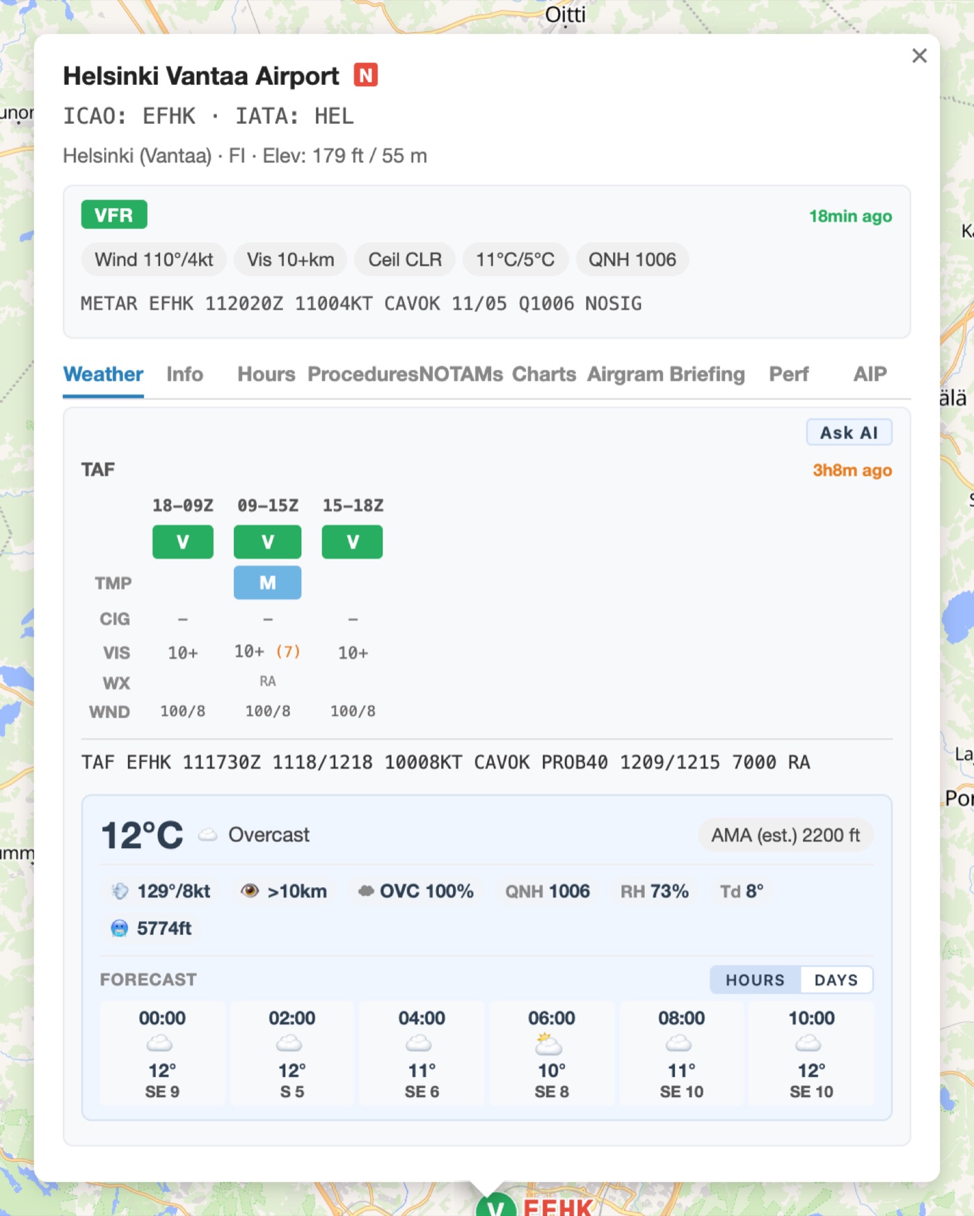
METAR, TAF and full airport briefing
The airport popup gives you everything you need for a briefing in one click: METAR, TAF, Nordic LLF summary, Open-Meteo forecast — plus an AI summary if you want one.
- Live METAR (~5-minute refresh) with flight category colours (VFR/MVFR/BIR/IFR/LIFR)
- TAF visualised on a timeline — periods and changes at a glance
- LLF section in the popup — the area's Low Level Forecast right there
- Wind aloft (low): surface, 260 ft, 400 ft and 590 ft AGL
- Fog and freezing fog badges — blends METARs with FMI observations
- Ask AI button: plain-language summary of METAR, TAF and the forecast
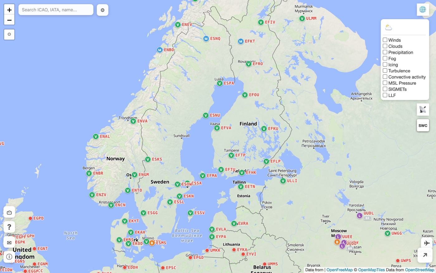
Weather layers, radar and satellite
Stack animated weather layers on the map and scrub time up to 7 days ahead. Radar and satellite imagery are selectable from the same menu.
- Wind as animated particles at selectable flight levels
- Cloud cover split by low / mid / high (or combined)
- Rain and snow with intensity grading
- Coastal fog detection (FMI observations + METARs combined)
- Icing risk based on humidity and temperature
- Turbulence from vertical wind shear and satellite-derived data
- Convective activity: CB/TCU markers, lightning symbols, severity grading (TCU → SEV CB) with estimated cloud tops — CIN-aware algorithm filters out capped cases
- MSL isobars with pressure centres
- Radar: RainViewer + FMI precipitation radar with +4 h FMIPPN nowcast
- Satellite: EUMETSAT and NASA GIBS daily true-colour
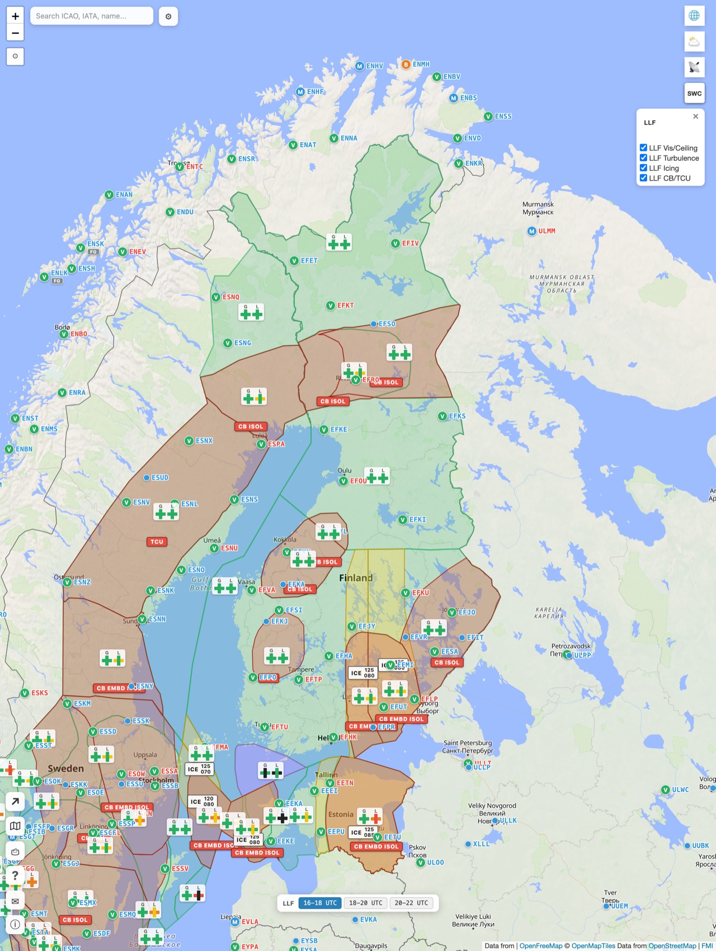
Nordic Low Level Forecast (LLF)
The professional low-level forecast directly on the map — no more juggling PDFs from different national services.
- Dedicated LLF panel: VeryLightIcing, Turbulence, Icing, OB/TCU
- Area boundaries colour-coded and refreshing per time period
- Sourced from FMI, SMHI, DMI and Met Norway
- Also shown as a text summary inside the airport popup
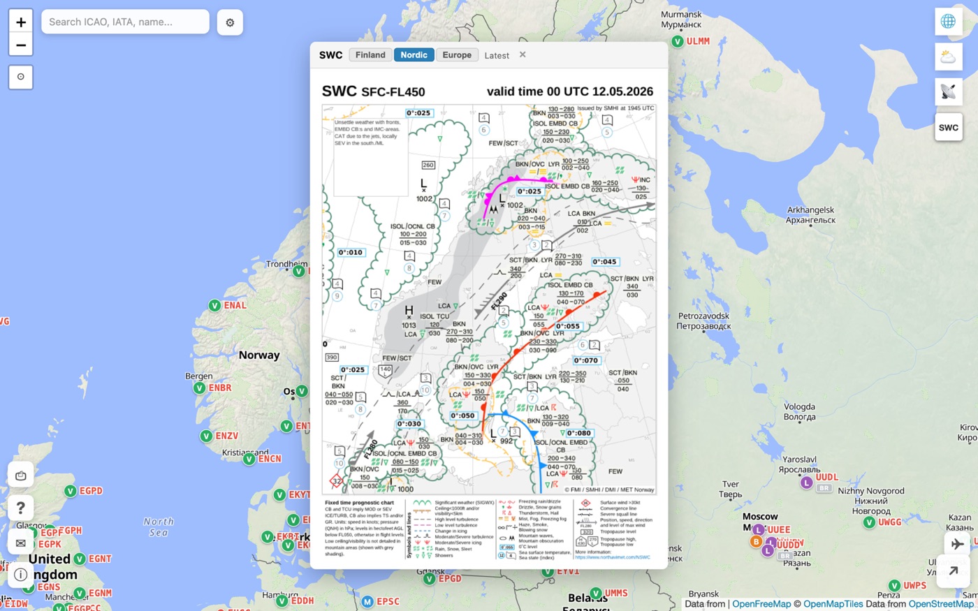
SWC, SIGMETs and FMI warnings
Official weather products embedded on the map: significant weather forecast charts, international SIGMETs and Finland's own MeteoAlarm warnings.
- Real-time SIGMETs as polygons (NOAA AWC feed, worldwide)
- Significant Weather Charts (SWC): Finland, Nordic, Europe
- FMI warnings: MeteoAlarm-coloured polygons (yellow / orange / red) for Finland-specific hazards — strong wind, snow load, freezing rain, thunderstorm, forest fire, frost
- Click a warning: headline, validity, description and peak wind
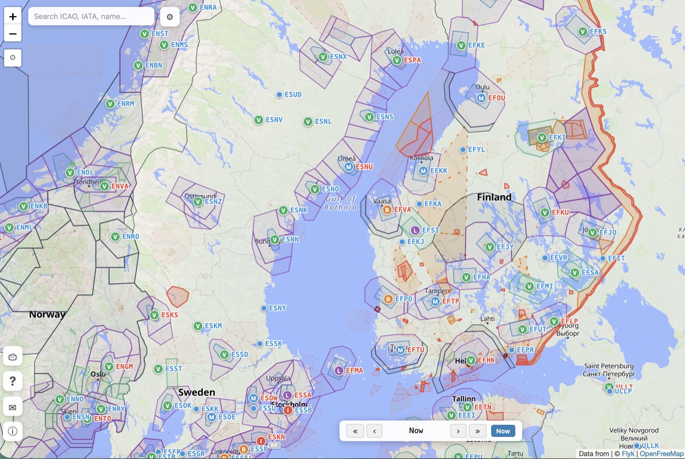
Airspaces, restricted areas and ACC sectors
Terminal airspaces (TMA, CTR) and restricted areas (R/D/P) appear on the map, but more importantly you see which areas are active right now.
- TMA and CTR with frequencies and vertical limits
- Restricted area colour shows the type (R/D/P) and line style shows activation: solid = active now, dashed = activates today
- NOTAM-triggered activations marked separately
- TSA/TRA reservation calendar (daily AUP/UUP, Flyk source)
- ACC sectors: Finland, Sweden, Norway, Denmark, Estonia, Latvia — callsigns and frequencies on click
- Free routes and conditional routes (CDR)
- OpenAIP data, supplemented in Finland by Flyk's wider R/D/P coverage
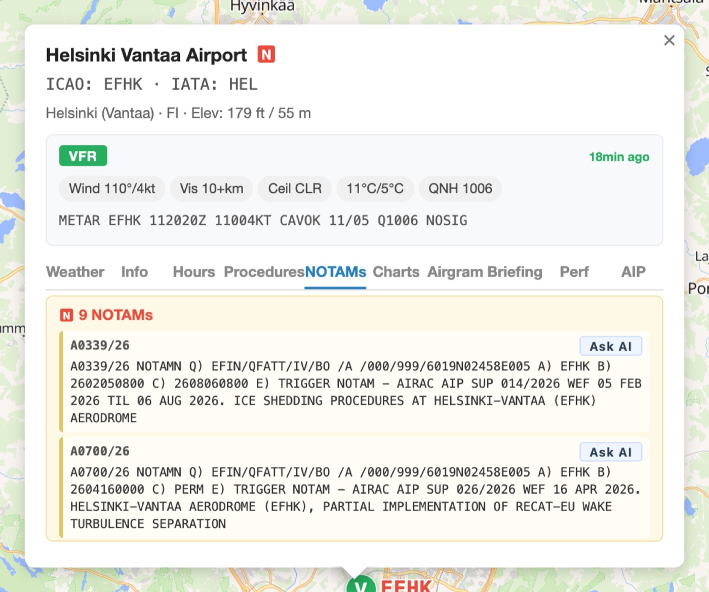
NOTAMs
Active NOTAMs listed and pinned on the map. An AI-assisted summary helps you parse the hard-to-read messages — but always verify with the official source.
- Active NOTAMs along your route and at destination
- Plain-language summary via AI (note: does not replace the official source)
- Filter by time window and severity
- NOTAM-triggered airspace activations also appear on the airspace layer
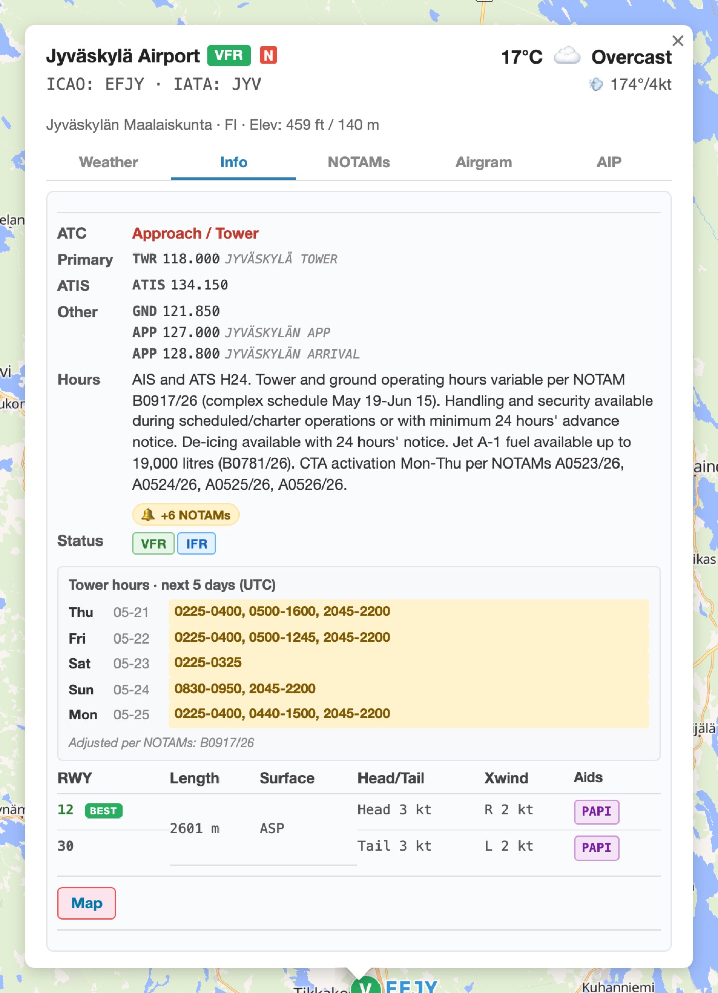
Airport data
Over 22,000 airports worldwide — deeper AIP-derived data for the Nordic countries. Everything in one Info tab.
- Runways: length, surface, approach lights, PAPI
- Automatic crosswind computation for the current METAR — best runway highlighted
- ATC frequencies: TWR, ATIS, APP, GND, RADAR, DEL, APRON
- Fuel grades (AVGAS 100LL, JET A-1, MOGAS)
- Tower and AFIS operating hours from AIP — plus a 5-day schedule with NOTAM adjustments
- NOTAM amendments reflected in the operating-hours table
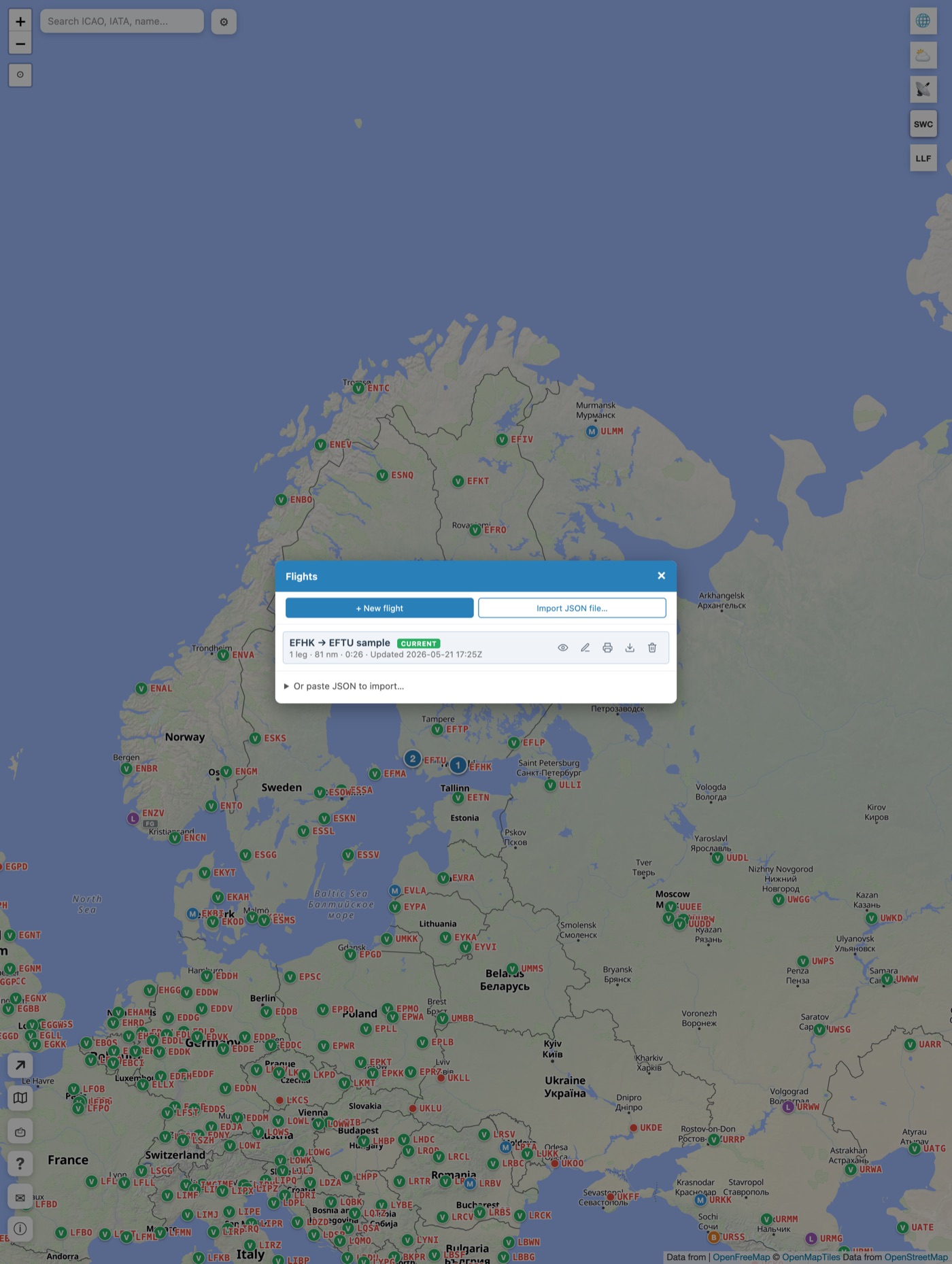
Flight Planner — multi-leg flight planning
Plan a multi-leg flight by clicking waypoints on the map. Save your routes to a library, export them as JSON, or share them with colleagues.
- Add waypoints by clicking or by searching with an ICAO code
- True and magnetic tracks, distances and estimated times en-route
- IAS/TAS input with Ground Speed corrected for wind
- Aircraft profile presets (DA62, DA40, SR22, C172/182, PA28, generic GA tourer)
- Edit-on-map mode: drag waypoints into place
- Bulk coordinate paste — drop in a route as text
- Flights library: save, load, import/export JSON, toggle on the map
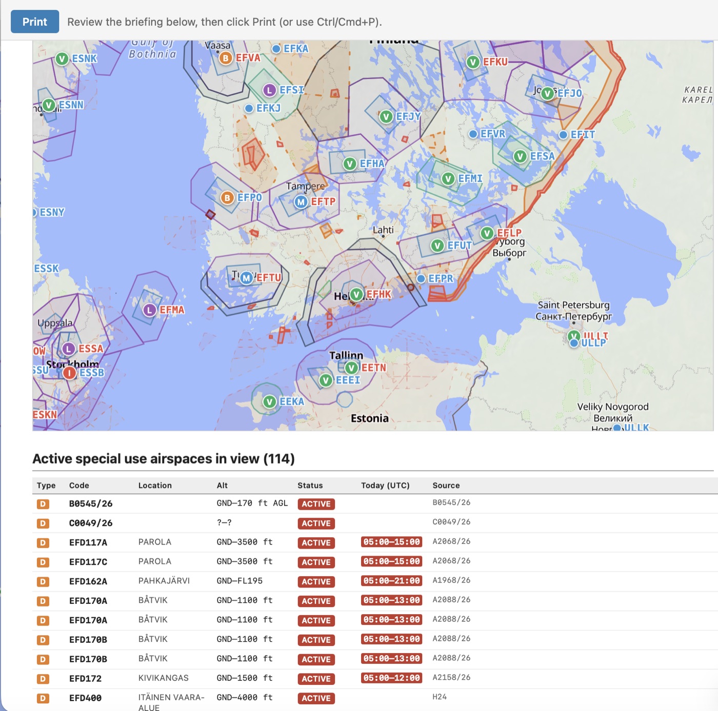
Printable briefing
One click gives you a printable, landscape A4 briefing that covers the whole route — ready for the cockpit.
- Cover page with the current map view
- Landscape navlog — one page per leg
- Airgram per leg — vertical cross-section for each leg
- AI briefing per leg: METAR/TAF for departure and destination, SUA within a 30 nm corridor, SIGMETs along track
- Appendices: active airspaces, NOTAMs, SIGMETs, route airports, SUA table
- PIC signature lines
- Also savable as a PDF for sharing
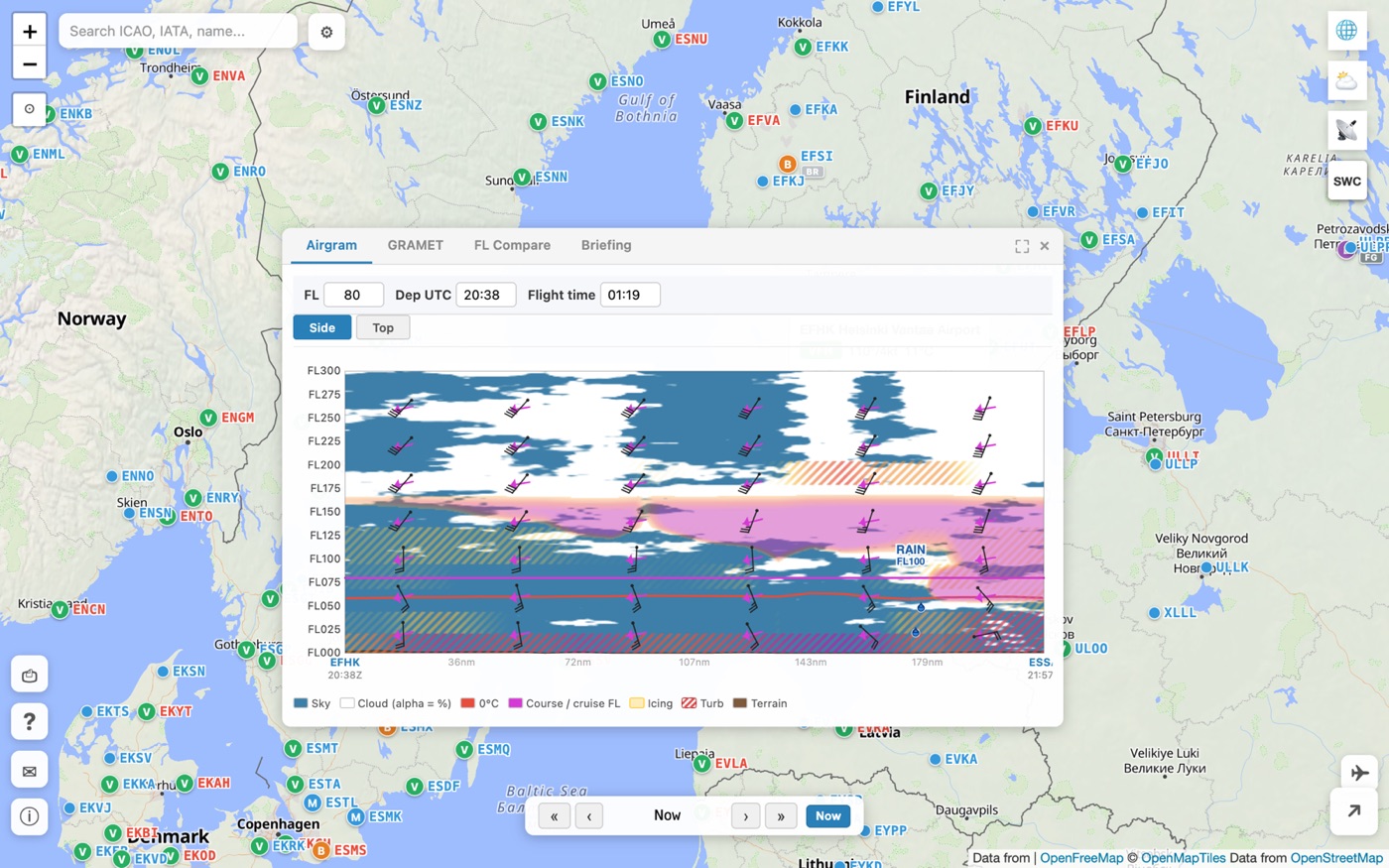
Airgram — vertical cross-section
Vertical atmospheric cross-section over 24 hours — clouds, wind, icing and turbulence at a glance. Available both per airport and over an entire route.
- Airport popup has its own Airgram tab — 24-hour vertical profile for the airport
- Route airgram: draw a line or use a Flight Planner route
- Date and time selector
- Drag freely and resize — also works on a phone
- Cloud layers, icing risk, turbulence and wind barbs
- Helps pick a safe flight level
- Save the airgram route straight into Flight Planner
Sign in and sync across devices
Optional email/magic-link sign-in makes the app personal: your saved flights, preferences and aircraft profiles travel with you between devices. Start a briefing on your phone, finish it on your desktop, open the route on a tablet for the flight.
- Sign in with an email magic link (no passwords) or your Google account
- Flight Planner flights sync automatically
- Weather-layer preferences and aircraft profiles travel with you
- Long session (~1 year) — no constant re-login
- Anonymous use still works — an account is entirely optional
Installable and works offline
Prepare Flights is a Progressive Web App (PWA) — install it to your home screen and use it like a native app. A comprehensive offline cache keeps the essentials available without a connection, and any changes you make sync back when the connection returns.
- Comprehensive offline data: weather, NOTAMs, airspace, AIP-based airport details and the last map view
- Offline write queue: edit flights and settings without a connection — changes upload automatically when you're back online
- Clear offline indicator in the PWA so you always know the state
- Install on iOS (Safari): Share button → Add to Home Screen
- Install on Android (Chrome): "Install app" prompt appears automatically
- Install on desktop Chrome/Edge: install icon in the address bar
- Mobile-optimised — works in both portrait and landscape